• HOME
  • About
  • Shop
  • Work With Me
  • Contact
  • Press
  • Nav Social Icons

  • Skip to primary navigation
  • Skip to main content
  • Skip to primary sidebar
  • Skip to footer
  • Home
  • About
  • Shop
    • Budget Travel Bible
  • Destinations
    • North America
      • Canada
      • Haiti
      • United States
        • Arizona
        • Florida
        • Hawaii
        • Idaho
        • Illinois
        • Montana
        • Nevada
        • New York
        • Oregon
        • South Dakota
        • Utah
        • Washington
        • Wisconsin
        • Wyoming
        • National Parks
    • Europe
      • Faroe Islands
      • France
      • Iceland
      • Ireland
      • Italy
      • Norway
      • United Kingdom
    • Asia
      • Maldives
    • Oceania
      • Hawaii
      • French Polynesia
        • Bora Bora
        • Tahiti
    • Hotel Reviews
  • Travel Tips
    • Budget Travel Tips
    • Travel Hacking
    • All Travel Tips
  • Travel Essentials
    • Gift Guides
    • Packing Lists
  • Travel Photography
    • Camera Gear
    • Photography Tips
    • Photography Guides
  • Contact
  • Work With Me
  • Mobile Menu Widgets

    Search

    Let's be friends!

    It’s the Nordic blood in me. ❄️ Ironically, It’s the Nordic blood in me. ❄️

Ironically, we did happen to “escape the cold” during this winter Rocky Mountain National Park trip. It was -45 at home and literally 70 degrees warmer in the Colorado mountains hahaha.
    Here’s our EXACT 3-day itinerary for Kyoto, Japa Here’s our EXACT 3-day itinerary for Kyoto, Japan, including our bullet train travel day. 🇯🇵 And, honestly, I wouldn’t change a thing.

Tips…

Go to Fushimi Inari Shrine and Arashiyama Bamboo Forest as soon as it starts to get light out in the morning (I’m talking like 5:30 a.m.) if you want any shot at taking photos without crowds!

Also… The monkey park was my favorite. 🙊
    Lack of oxygen was worth it. Location: Trail Ridg Lack of oxygen was worth it.

Location: Trail Ridge Road in Rocky Mountain National Park

Trail Ridge Road is the highest continuous paved road in the USA, peaking at over 12,180 feet of elevation. 🤯 As you could imagine, the road closes to vehicle traffic during the winter because of snow. BUT, you can still hike, snowshoe or cross-country ski on it in the winter!

We rented skis at Estes Park Mountain Shop, parked at the Many Parks Curve Overlook parking lot and skied away. ⛷️

Would you ski here?
    It’s literally 70 degrees warmer in Colorado. T It’s literally 70 degrees warmer in Colorado.

This whole weekend we joked that we were “escaping the cold” on this winter Rocky Mountain National Park trip because it was around 25 degrees Fahrenheit there and -45 degrees in Wisconsin.

All of the Denver locals were like, “You picked a cold week to be here.” And we were like, “No no… We picked the perfect weekend to be here.” 🤣

Tropical vacation for a Wisconsinite.
    Next destination? Points and miles millionaire 💸✈️ Come with me to strategically earn one million credit card points in one year without spending more than I usually do. Think I can do it? 

Follow @indigosahara for part three.
Travel Blog

Indigo Sahara

Travel Reviews, Guides, Tips & Travel Hacking

  • Destinations
    • North America
      • Canada
      • Haiti
      • United States
        • Arizona
        • Florida
        • Hawaii
        • Idaho
        • Illinois
        • Montana
        • Nevada
        • New York
        • Oregon
        • South Dakota
        • Utah
        • Washington
        • Wisconsin
        • Wyoming
        • National Parks
    • Europe
      • Faroe Islands
      • France
      • Iceland
      • Ireland
      • Italy
      • Norway
      • United Kingdom
    • Asia
      • Maldives
    • Oceania
      • French Polynesia
        • Bora Bora
        • Tahiti
      • Hawaii
    • South America
    • Hotel Reviews
  • Travel Tips
    • Budget Travel Tips
    • Travel Hacking
    • All Travel Tips
  • Travel Essentials
    • All Travel Essentials
    • Packing Lists
    • Gift Guides
  • Travel Photography
    • Camera Gear
    • Photography Tips
    • Photography Guides

Hiking Trail Of Cedars To Avalanche Lake

By: Indigo Sahara, M.A. | Published: October 21, 2025 | Updated: October 21, 2025

Hiking Trail Of Cedars to Avalanche Lake in Glacier National Park? This blog post will tell you everything you need to know, including trail stats, important tips, and whether or not the hike is worth it.

Table of Contents

Toggle
  • Trail Of The Cedars Hike
  • Avalanche Lake Hike
  • More Glacier National Park Guides
  • Save This Guide To Hiking Trail Of Cedars To Avalanche Lake

Trail Of The Cedars Hike

Hiking Trail Of Cedars To Avalanche Lake
Trail Of The Cedars boardwalk

Distance: 0.9 miles
Elevation gain: 49 feet
Trail type: Loop
Difficulty: Easy

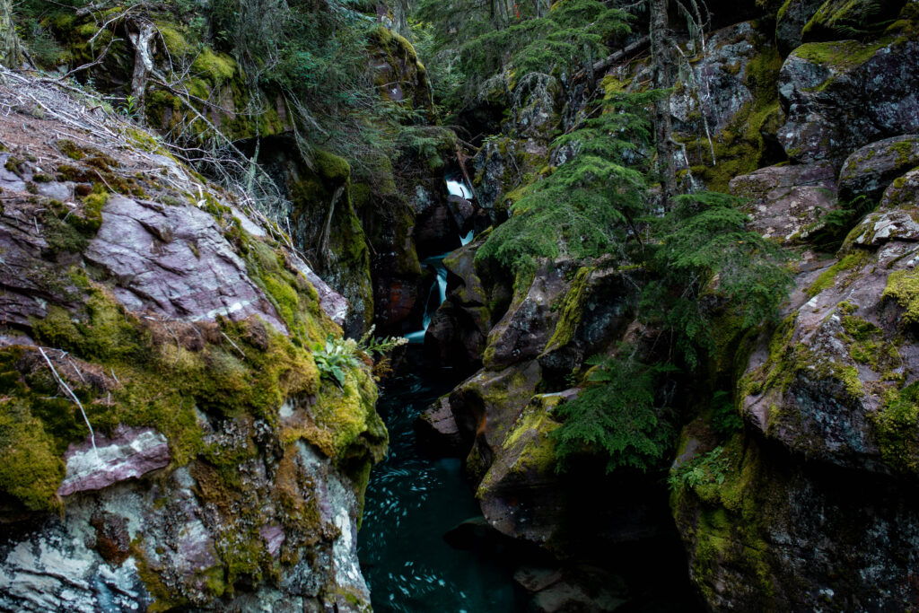
The Trail Of The Cedars hike (AllTrails map here), also known as “Trail Of Cedars,” is one of the only rewarding hikes in Glacier National Park under one mile in length. On the Trail Of Cedars, you walk among giant ancient cedar trees and miniature waterfalls in dense green forestry. It’s mostly flat, with only 49 feet of elevation gain. And, it’s one of the most accessible hikes in Glacier National Park, as a good portion of this loop trail is on flat boardwalk.

trail of cedars glacier national park
Gorge view along Trail Of The Cedars

To begin this hike, you’ll park in the Avalanche Creek Picnic Area parking lots and start at the Trail Of The Cedars trailhead. However, these parking lots are extremely competitive and usually fill up by 7:00 a.m. I highly suggest you get to the trailhead before 6:30 a.m. to secure a parking spot. We arrived at the trailhead at 6:30 a.m., and the first lot was already completely full. We saw a lot of people parking far down the street for this hike, which adds quiet a bit of mileage plus walking on the extremely busy Going-To-The-Sun Road. Moral of the story, get there early.

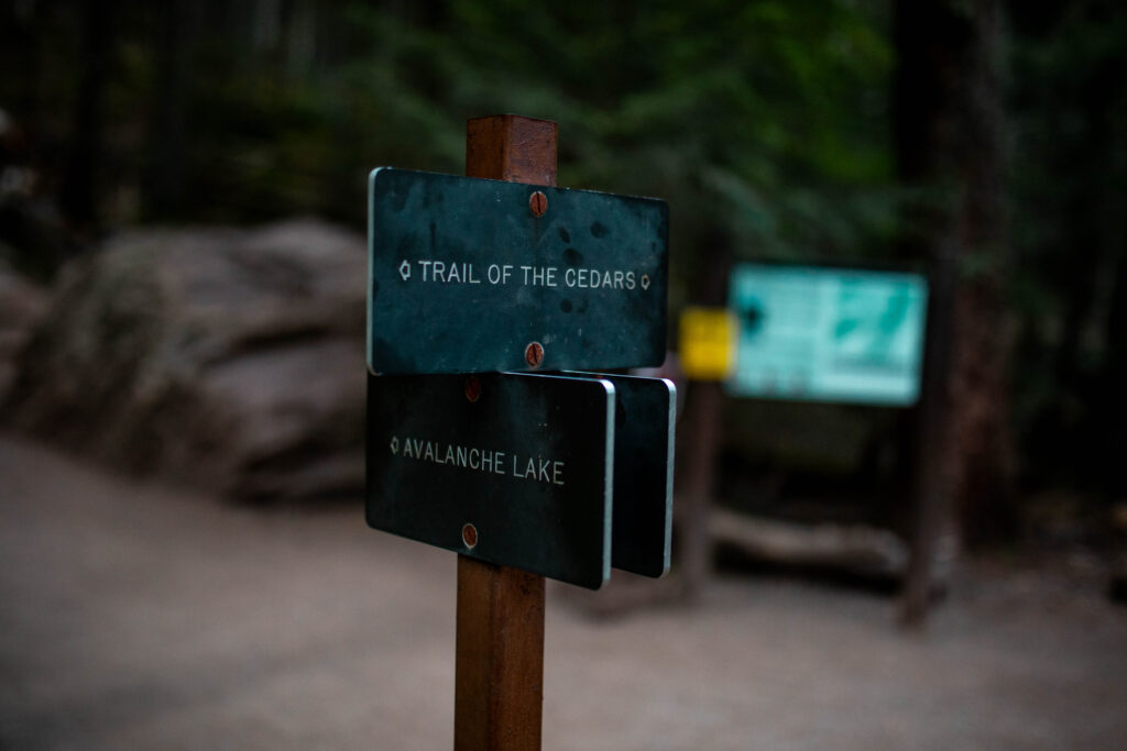
Does Trail Of Cedars Lead To Avalanche Lake?

Trail Of Cedars does not lead to Avalanche Lake itself. Rather, Trail Of Cedars leads to the Avalanche Lake trailhead. The Trail Of Cedars loop trail passes, and therefore leads to, the Avalanche Lake trailhead. This means, the Avalanche Lake hike is a separate spur trail that is a great addition to the Trail Of Cedars if you want to do both. In fact, if you want to hike to Avalanche Lake, I highly recommend finishing the Trail Of Cedars on your way back to complete the loop. Although, hiking Trail Of Cedars to Avalanche Lake does add a significant amount of time, mileage and elevation gain. I’ll tell you everything you need to know about hiking both trails soon.

trail of cedars
Trail Of The Cedars to Avalanche Lake trailhead

Is Trail Of Cedars Worth It?

The Trail Of Cedars loop trail is definitely worth it given its short distance, especially for families with young children and/or accessibility needs. It’s a very pleasant walk even if you don’t do the full hike up to Avalanche Lake. Although, to play devil’s advocate, if you’re an avid hiker expecting an epic view like other parts of Glacier National Park have to offer, you’ll definitely want to do the full Avalanche Lake hike.

How Hard Is The Trail Of Cedars?

Without the full hike to Avalanche Lake, the Trail Of Cedars is very easy thanks to its short distance and minimal elevation gain. If you’re looking for accessibility and only want to walk the boardwalk, start the Trail Of Cedars from the lefthand trailhead, taking the loop trail counterclockwise. At the parking lot, there are two trailheads at either end of the lot. Because the trail is a loop trail, you can start at one trailhead and come out from the other. The boardwalk is located at the left trailhead. Otherwise, you may need all-terrain wheels to complete the whole loop.

Avalanche Lake Hike

trail of the cedars
Avalanche Lake

Distance: 5.9 miles
Trail Of Cedars to Avalanche Lake trailhead distance: 0.45 miles
Elevation gain: 757 feet
Trail type: Out-and-back
Difficulty: Moderate

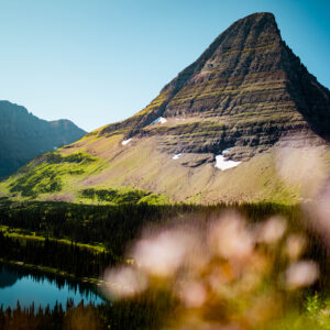
Glacier National Park only has a handful of epic hikes that are under 10 miles in length. The Avalanche Lake hike is one of them. Considering Avalanche Lake will only take a few hours of your Glacier National Park itinerary, the jaw-dropping lake views at mile three are so rewarding. At Avalanche Lake, you’re surrounded by massive mountains, numerous waterfalls and gatorade blue glacial water. Additionally, the water at the shoreline is so calm and crystal clear that you can see through it like glass.

avalanche lake glacier national park
Water clarity at Avalanche Lake

Although this hike is very popular, you can still find quiet areas of the lake if you hike down the shoreline about a quarter mile away from the trail opening. Down the shoreline, you’ll also see a better reflection of the mountains over the lake, especially if you go mid-morning. The hike’s popularity also means that you’re less likely to encounter a bear, but it’s crucial you carry bear spray anyway.

avalanche lake trail
Reflections at Avalanche Lake

Is Avalanche Lake Worth It?

The Avalanche Lake hike is 100% worth it. If you are physically able, do it. Honestly, even though the hike adds a whopping five miles to the Trail Of The Cedars, as an avid hiker, I wouldn’t do Trail Of The Cedars again without adding the hike Avalanche Lake.

How Hard Is The Avalanche Lake Hike?

The Avalanche Lake hike has moderate difficulty, with a decent about of distance and certainly enough elevation gain to get your heart pumping. Most healthy, physically active visitors should not have an issue doing this hike, but keep the distance and elevation gain in mind. The elevation is fairly gradual, but take breaks if you need to. Avid hikers will find this hike to be one of the easiest lake hikes in Glacier National Park. After all, Avalanche Lake is one of the best hikes in Glacier National Park under 10 miles.

Hiking Trail Of Cedars To Avalanche Lake
Avalanche Lake

More Glacier National Park Guides

Driving Going-To-The-Sun Road: Everything You Need To Know
Epic 7 Day Itinerary For Glacier National Park
Lake McDonald Montana: Glacier’s Best Beach, Boating + Apgar Village

Save This Guide To Hiking Trail Of Cedars To Avalanche Lake

Save this guide to hiking Trail Of Cedars to Avalanche Lake for easy access later by sharing to socials.

  • Share on Facebook Share on Facebook
  • Share on Pinterest Share on Pinterest
  • Share on Reddit Share on Reddit
  • Share via Email Share via Email

By: Indigo Sahara, M.A.

About Indigo Sahara, M.A.

Indigo Sahara, M.A., is the founder and CEO of the Indigo Sahara travel blog. Since earning her master's degree in global leadership, she has traveled to more than 20 countries. Now, her goal is to make travel accessible to all by teaching others how to travel on a budget. She writes world travel guides and travel hacking tips weekly.

you’ll also love

21st birthday in vegas13 Fabulous Things To Do On Your 21st Birthday In Vegas
one day in death valley national parkDeath Valley National Park One Day Itinerary To See Everything
10 Things To Do On Washington Island All Year Round

Get exclusive content.

Stay up-to-date & receive the latest travel guides and tips right to your inbox.

Reader Interactions

Leave a Reply Cancel reply

Your email address will not be published. Required fields are marked *

Next Post >

30 Bible Verses About The Mountains

Primary Sidebar

Meet Indigo

Meet Indigo
hello!

I'm Indigo, a 27-year-old full-time travel blogger who's on a mission to make travel accessible to all through budget travel tips and bucket list destination guides.

Read More

Let's Be Social

get exclusive content

Search The Blog

Pinterest

Facebook

Indigo Sahara

Catch Up On The Lastest Posts

Follow On Instagram

@indigosahara

It’s the Nordic blood in me. ❄️ Ironically, It’s the Nordic blood in me. ❄️

Ironically, we did happen to “escape the cold” during this winter Rocky Mountain National Park trip. It was -45 at home and literally 70 degrees warmer in the Colorado mountains hahaha.
Here’s our EXACT 3-day itinerary for Kyoto, Japa Here’s our EXACT 3-day itinerary for Kyoto, Japan, including our bullet train travel day. 🇯🇵 And, honestly, I wouldn’t change a thing.

Tips…

Go to Fushimi Inari Shrine and Arashiyama Bamboo Forest as soon as it starts to get light out in the morning (I’m talking like 5:30 a.m.) if you want any shot at taking photos without crowds!

Also… The monkey park was my favorite. 🙊
Lack of oxygen was worth it. Location: Trail Ridg Lack of oxygen was worth it.

Location: Trail Ridge Road in Rocky Mountain National Park

Trail Ridge Road is the highest continuous paved road in the USA, peaking at over 12,180 feet of elevation. 🤯 As you could imagine, the road closes to vehicle traffic during the winter because of snow. BUT, you can still hike, snowshoe or cross-country ski on it in the winter!

We rented skis at Estes Park Mountain Shop, parked at the Many Parks Curve Overlook parking lot and skied away. ⛷️

Would you ski here?
It’s literally 70 degrees warmer in Colorado. T It’s literally 70 degrees warmer in Colorado.

This whole weekend we joked that we were “escaping the cold” on this winter Rocky Mountain National Park trip because it was around 25 degrees Fahrenheit there and -45 degrees in Wisconsin.

All of the Denver locals were like, “You picked a cold week to be here.” And we were like, “No no… We picked the perfect weekend to be here.” 🤣

Tropical vacation for a Wisconsinite.
Next destination? Points and miles millionaire 💸✈️ Come with me to strategically earn one million credit card points in one year without spending more than I usually do. Think I can do it? 

Follow @indigosahara for part three.

Footer

Blog

  • Destinations
  • Travel Tips
  • Travel Essentials
  • Travel Photography
  • Camera Gear

Info

  • Home
  • About
  • Shop
  • Contact
  • Work With Me
  • Portfolio
  • Press
  • Privacy Policy
  • Refund And Returns Policy

stay in the know

Copyright Indigo Sahara © 2026 · Theme by 17th Avenue

We use cookies to provide you with a great user experience. By using our website, you accept our use of cookies.Accept